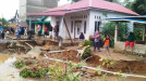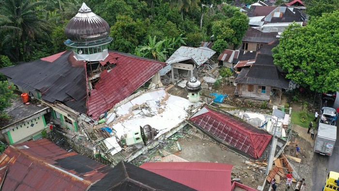
West Pasaman, sumbarsatu.com—The Meteorology, Climatology and Geophysics Agency warned of a further threat after the 6.2 magnitude earthquake that occurred on Friday, February 26, 2022. The threat referred to by the Meteorology, Climatology and Geophysics Agency is in the form of potential landslides, floods, and flash floods in the upstream area of the slopes of Mount Talamau.
"For the earthquake, God willing, the development is far sloping. This means that the aftershocks that occur are getting weaker towards stability," said the Head of BMKG, Dwikorita Karnawati in West Pasaman Regency, West Sumatra, Sunday (27/2/2022).
Dwikorita said that what currently needs to be watched out for is the potential for hydro-meteorological disasters in the form of potential floods or flash floods and landslides, considering that it is still the rainy season. People who live along the river on the slopes of Mount Talamau must be more alert and alert because this potential can occur at any time.
"So the public's awareness must shift, no longer about earthquakes but disasters caused by the rainy season. Based on the survey results, it was identified that the sediment flood overflow reached a radius of approximately 200 m from the river bank. So residents who live and work along the river that flows from the upper slopes of Mount Talamau are advised to avoid the zone within a radius of 200 meters from the river bank, if it rains on the slopes of the mountain. This situation is expected to last until March - April," he added.
Dwikorita said that currently the Meteorology, Climatology and Geophysics Agency together with the River Basin Center of the Ministry of Public Works and Public Housing continue to carry out mitigation efforts to reduce the impact if a hydrometeorological disaster strikes at any time.
Prevention is carried out by the Meteorology, Climatology and Geophysics Agency by continuously monitoring the weather and rain intensity, as well as BWS dredging mud sediments or avalanche material that occurred due to the earthquake and was swept away by rain or river flow, using heavy equipment, so that the water flow does not overflow into residential areas.
This dredging effort is also at the same time preventing the formation of blockage of landslide sediment material in the river valley. These material blockages often occur due to landslides during earthquakes, and it would be dangerous to stem the flow of rainwater and river flows from upstream. The reason is, the dam can burst at any time if water continues to accumulate and suppress, along with an increase in rainfall.
The Meteorology, Climatology and Geophysics Agency, he continued, continued to more intensively monitor the weather using weather radar, as well as provide forecasts and early warnings of potential extreme weather in the upstream area of the slopes of Mount Talamau.
"You don't have to believe in hoaxes or lies that are deliberately spread to scare the public. Make sure the information obtained is valid directly from the BMKG. Please continue to monitor the The Meteorology, Climatology and Geophysics Agency communication channels. Not only updates about earthquakes, but also weather conditions and early warnings," he concluded.
"We are also identifying the hazard zone at the river border and slope border," he said.
Do Earthquake Survey
Meanwhile, regarding the earthquake, Dwikorita said that after the earthquake hit West Pasaman, the Meteorology, Climatology and Geophysics Agency immediately moved to conduct a survey to map the level of soil vulnerability to earthquake shocks which was verified by mapping the level of building damage.
The level of soil vulnerability is mapped by measuring various types of soil and rock around the epicenter.
The Meteorology, Climatology and Geophysics Agency also continues to monitor and map aftershocks, to predict when the aftershocks will end.
The survey results are prepared to be recommended to the Regional Government, to strictly observe the "building code" for earthquake-resistant building standards, especially in zones that are prone to earthquake shocks.
From the results of these measurements, it will be factually mapped which zones are vulnerable to strong shocks in the future.
"Later on, it will be verified which areas have high, medium, and low levels of vulnerability or shocks, as information for local governments to rebuild the region," he explained.
On this occasion, Dwikorita also appealed to the earthquake victims to return to their respective homes if the condition of the house was still intact and categorized as livable, and the house was outside the 200 meter zone from the river bank, considering the aftershocks that occurred after the earthquake. main is getting weaker.
"You don't have to believe in hoaxes or lies that are deliberately spread to scare the public. Make sure the information obtained is valid directly from the BMKG. Please continue to monitor the BMKG communication channels. Not only updates about earthquakes, but also weather conditions and early warnings," he concluded.
In the field survey, the Head of the Meteorology, Climatology and Geophysics Agency, accompanied by the Head of the Technical Seismology Center - Rahmat Triyono, the Head of Regional 1 Agency for Meteorology, Climatology and Geophysics - Darmawan, as well as the provincial Meteorology, Climatology and Geophysics Agency Coordinator and five station heads Meteorology, Climatology and Geophysics in the West Sumatra region.
The Meteorology, Climatology and Geophysics Agency also coordinates with the National Disaster Management Agency, the Regent of West Pasaman Regency and their staff, especially the Head of the Regional Disaster Management Agency and the Head of the Kominfo Service, as well as synergizing with the local River Basin Center Team. SSC/MN